Showing posts with label Biking. Show all posts

Sunday, February 01, 2015

Animals, Butterflies and Dinosaurs

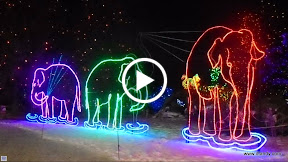
We got to go to the Zoo when frosty winter night to see Zoo Lights.  Wow!  Was that amazing!  A lot of fun, albeit quite cold.

Wish I had a tripod to eliminate much of the blur.

Elizabeth got a big girl’s two-wheel bike from Mom and Dad for Christmas and Santa gave her a red Scooter, just as she wished for.

One of my personal favorite places to go to on a cold winter day…is the (humid and warm) Butterfly Pavillion.

I took Elizabeth to see the Dinosaur Museum one day.  It was small, and there wasn’t a whole lot of engagement for her at this age, but still worth it to pop in.

So, since we were finished in a relatively short time, we went for a hike at Red Rocks down the street.  It was chilly, with rain & snow in the clouds, and lots of mud on the ground.

She loved it.

We slip-slided all over holding eachother’s hands to stay upright.  And she was a trooper.  Three-quarters of the way in, she got tired, but kept hiking because there was no other safe way to carry her.  Thank goodness for chewy fruit treats to re-energize her.

And, thank goodness for some good hiking boots!  Found this purple pair not too long ago and we love them!

We took her to one of the Mesa trails in Superior for her to ride and us to go for a walk.  When she is on her Strider, she is fast and I mean FAST!  We will literally have to RUN to keep up with her when she gets going.  I’m finally getting some exercise again.  Woo-hoo!

We had put both of her bikes in the car, and took a different trail around the lake using her new bike.  It’s amazing how quick she is learning.  This was only the third (?) time outside on her new pedal bike and we’re definitely seeing more confidence and skill.  We still have to hold her seat and help her control the steering some, but soon we’ll be able to let go.  IF we can keep practicing.

She was so fast pedaling this time out that I was the one slowing her down.  It is much harder than I thought to run while hunched over holding her seat and/or handle bar.  Not so good for these middle-aged backs!

More pictures in January’s Album

Monday, September 09, 2013

Mountain Biking! WooHoo!

It has been forever since I’ve been on my mountain bike with the intention of riding a trail!  No child trailer attached, no concrete, my hubby and biking partner by my side…it was wonderful!

We just rode Marshall Mesa Trail east of Hwy 93, with views of the Flat Irons in Boulder.  It was a stormy sky which added such beauty.

In the distance we could make out the V-shaped opening marking El Dorado Canyon State Park.

And there was a creek near the trail that kept the cattle watered, too.

But what did I like the most?  Going fast of course!  To be able to zip along the trail and bounce over rocks and feel my muscles working to stay upright with tears in my eyes from the wind.  What a flashback for me to those pre-Elizabeth days when we did this traveling.  What a hoot and a joy!  I can’t wait to teach Elizabeth how to ride the trails, because something tells me she will love it as much as I do.  Many thanks to Steph for watching Elizabeth for a short two-hours so we could ride together.  Love you.

Sunday, November 15, 2009

Temperature Changes

Last week was beautiful – in the 60’s and 70’s and sunny.  We decided to take advantage of it a couple of days, knowing that the temps were going to change radically this weekend.

So Wednesday we took our mountain bikes to Standley Lake.  I have to get comfortable on these beginner trails before we try anything more aggressive.  Plus, we didn’t have that much time and Standley is close by with pretty views of the mountains.

Plus, I love the Prairie Dogs that call this park home…

Look!  A beach…

Then on Thursday we took a road bike ride along the Ralston Creek trail and tackled the Arvada Reservoir twice (down the switchbacks, then turned around and rode up).  It was a gorgeous day in the mid-70’s…hard to imagine that the next day was going to look like this:

….Kids playing pee-wee football in the snow.  We got several inches Friday night and then more late Saturday.

Ok, time for me to run now – Andy and I are going out to play in the snow.  Darn, I wish we still had our sand-saucers…they’d make great sleds right now.

Monday, September 28, 2009

What Do You Do on your Anniversary?

Most couples would spend the day doing something romantic, right?  We, on the other hand, go for a 34-mile bike ride.  And I wouldn’t have it any other way.  Fourteen years, and I’m still happy to say that Andy is my best friend and the love of my life. 

We have a lot of the same interests and enjoy doing it together.  So spending a few hours biking around town was a perfect way to celebrate our anniversary. 

We rode the Clear Creek Trail east, then connected to the Ralston Creek trail northwest, before riding south on some designated bike routes back to the Clear Creek Trail to make it a loop ride.

Most of this was “new territory” for us.  I’m hoping that biking these trails will help improve my biking – in Florida we’re not used to curvy roads and hills.  The Creek Trails are quite curvy as they zigzag back and forth over the creeks.  At the western end of Ralston we got to tackle the hills around the Arvada Reservoir.  A couple of laps around that reservoir would be great hill practice for me.

After we reached the Clear Creek Trail near Golden, Andy realized that we were only three miles from our favorite local microbrewery – Golden City Brewery.  So off we went – in the opposite direction!  He always lies, too, saying he’s just going to get “one beer”.  Yesterday, we ended up with “one”.  But it was one pitcher.  Cheers!

Saturday, September 19, 2009

Biking South Valley Park

I searched all morning for “beginner” mountain biking trails.  I didn’t want a paved path.  I was looking for an easy single-track with a scenic opportunity.  I wanted to *experience* a little Colorado.  We’ve been so busy all week, I just needed some scenic mountain fun.

Well, we found it at South Valley Park.  This Jeffco Open Space is south of Morrison – where the Red Rocks Amphitheatre is.  South Valley had the stunning, jutting red sandstone formations that I just love out here in the west.  Like the whole landscape had just collided and erupted with red rocks.

Here was our ride down Coyote Song Trail:

One of the trails on my wish list was Grazing Elk Trail…sounds like I should’ve seen some elk there, right?

Great views, but no elk.  Apparently they don’t come down to this Elk Meadow until snow fall in the mountains drives them down.

Not all of the trails were ‘easy’, but they still would be “beginner” trails in Colorado I guess.  Some required walking, while getting up and over Lyons Back and Pass Trail required a bike-carry up the steep rock staircase.  Our biggest challenge was hitting the hills at this elevation, though (about 6,100’).  We are still feeling it, whether we’re biking or running – breathing has been hard.

I have a couple of more photos on WebAlbums.

Sunday, September 13, 2009

From Wheat Ridge to Denver on the CCT

Last Monday (Labor Day) we decided to take a break from my computer woes and get on our road bikes to explore the trail system. 

We hopped on the Clear Creek trail and went northeast.  The plan was to connect to the South Platte River Trail to take us south into downtown Denver.  Of course, we got a little lost on the way…the trails are great, but there are numerous trails and spurs and they aren’t necessarily marked clearly (or at all).  So getting lost is not uncommon until you learn your way.

Here’s a rough map of our route (we went off the map, actually):CCT_SPT See a more detailed map of Denver’s bike trails.

Needless to say our 42 mile bike ride could’ve been a lot shorter if we just used some bike routes or on-street bike paths and went due east of our location.  But the off-road bike paths are car-free – and that’s why we love them.  It was about the ride, not the destination.  Although, having lunch near Confluence Park (where 16th Street meets the river), was pretty nice.

PS:  I got another flat on the way home.  So when Andy saw that a local bike shop was offering a women’s only Bike Maintenance Clinic he sent me back to school.  It was fun, but isn’t any event more fun when they serve wine?

Sunday, August 30, 2009

Wheat Ridge, CO - Here for a Month

We hope to be here in Colorado til late October or whenever the cold weather chases us out.  Wheat Ridge is a suburb of Denver.  It's on the west side, halfway to Golden, CO (where we've stayed in years past).  The RV Park itself isn't fancy, but we chose it because of it's location.

It borders an Open Space, and has immediate access to the Clear Creek Trail.  We could go from Golden to downtown Denver on this trail.  Denver offers 850 miles of bike paths.  That is impressive.  And considering that a lot of these trails are built with underpasses or bridges to minimize road crossings, it's even better.  I'm sure I'll be telling you more about our biking over the next two months.

So far, though, we think we made a good choice.  There are several highlights to our location besides the bike trail:

We have a couple of bunnies who call our campsite home...looks pretty comfy, eh?

IMG_3094

There is a farmer's market two blocks away - easy to walk to...

Camping World is one mile away, and easily accessible by bike...

Applejacks (the largest liquor/beer store in the state...or the world?) is up the street...with local Colorado brews....

The Wheat Ridge Recreation Center is less than one mile by bike - offering an Olympic size pool - am I finally going to get back in the water??  Hope so...

And Andy has already found Large Marge's Philly Cheesesteaks and Philly Soft Pretzels...across the street from the Rec Center.  Already tested and proven to be the real thing.  Something tells me on Lap Swimming days, he's going to want a cheesesteak.

The only drawback so far?  Apparently besides the bunnies, we also have a skunk.  Eeewwww.

Sunday, August 23, 2009

Carthage, MO - Jack Ruby or Ruby Jack?

I kept mixing up the name of this 16-mile trail that runs from Carthage to Joplin, MO.  It is the Ruby Jack Trail.  We attempted a bike ride on it.  The website warned it is a rough ride, and indeed it is.

Large gravel (uncomfortable to ride on) led to a portion of the trail with lots of plants growing over the path.  It was natural on both sides of the trail, which was nice but offered no views.  We only rode about 7 miles total.

biking Ruby Jack

What was fun, though, was to count all the old railroad spikes strewn about and to try to find other pieces of the old rail line.

It would be a nice trail if/when they clean it up a little and crush some of the bigger gravel....which sounds like they are working on.

Friday, August 21, 2009

Van Buren, MO - On the River

Our initial plan was to only stay in Van Buren one night.  But after seeing that our RV park was right on the Current River (and it looked perfect for kayaking or tubing), we ended up staying for three nights.

Here's the pavilion which was our special place for happy hours and for working (WIFI was unreliable at our camp site) - not a bad office, though!

Andy at Big River RV Camp

We were practically within the Ozark National Scenic Waterways NPS boundaries.  Down the street was Big Spring - the largest single source spring in the world.  I'm not used to seeing springs that create rapids.

Big Spring

The water was a beautiful, crystal-clear blue green.  But a bit chillier than our springs in Florida.  It was 55 degrees.

Big Spring

We were able to squeeze in a multi-sport adventure one day.   We had thunderstorms one day, and threats of them the second day, but a window in the weather allowed us time to play.

Our multi-sport adventure was so we could self-shuttle for a one-way kayak down the Current River.  We drove our car to the boat launch in Big Spring Park.  Then rode our mountain bikes the 4-miles back to camp.  We used our mountain bikes because the road surface isn't the smoothest.  The area is within the Mark Twain National Forest.  This ride has ranked 'tops' as the hardest 4-mile bike ride of our lives.  Killer hills.  Worse than we expected - even after driving the road twice.

Andy Biking from Big Spring

After arriving back at camp on our bikes, we dragged our kayaks to the river's edge and dropped in.  I can't really say this was a "paddle", though.  It was more of a "float".  There was a good current on the Current and we reached the boat launch a little over an hour later (about 4-miles on the river, too, I'm guessing).  We saw one power boat our entire voyage.  Perfect!

Kayaking Current River to Big Spring

Funny.  In our rush to get out and play we forgot about some of the basics of safety.  No maps, no idea what the boat launch looked like from the river, no real knowledge of distance or expected time on the river, and so on.  So when an hour passed and we weren't sure if we missed the launch or not, we started to discuss survival tips if we had to sleep on the shore - thunderstorms, chilly nights, huge horse flies, etc.  But we're here to laugh about it, so no worries now!

When we were driving out of the park after our kayak-float, we stopped to admire the mist that was settling on the stream near Big Spring...

Mist over Big Spring

Normally you could see straight through the water and see the grasses below the surface.

Mist over Big Spring 

We only did a tiny, tiny part of this national park.  If we explored more, we could've found other springs, waterfalls, caves, hiking trails, and so on.  Worth a re-visit...

Monday, August 17, 2009

Aurora, KY - Biking the Land Between the Lakes

Sunday morning we got up early and went for a road bike ride.  The main north-south road in LBL is called The Trace (French for "path" since it's an old Indian path).  Although it has good road surface for riding, we decided to do more of the secondary roads to avoid traffic - although traffic seemed minimal, it still offered no shoulder and high speed traffic on The Trace. 

We rode 29 miles by looping together Mulberry Flat Rd, The Trace, Silver Trail Rd, and then doing all paved spur roads we could find -- to the Nature Station, to Honker Bay, to Energy Dam, and so on.  A great ride.  Hilly and curvy thru a forested area.  We thought our biggest dangers were keeping an eye out for the suicidal squirrels, the flocks of wild turkeys (which were HUGE by the way), and the multitude of deer which bounded across the roads.  But then Andy came down a hill and around a bend only to find that our paved road suddenly turned to gravel.  I saw him limping next to his bike and his frantic waving and was able to stop in time.  No blood, no injuries, just another flat tire.  Whew.  

The area we were riding in had signs about Eagle nesting, but we didn't see any unfortunately.  Stopping to look does kind of ruin your average speed, but riding bikes is a great way to explore versus being sealed up in a car. 

We're hoping to get either another road bike ride in during our stay, or get our mountain bikes out on some of these trails.  But the heat index hit 101 degrees one day, so if we can't do it first thing in the morning or near sunset, we'll be out of luck.

Tuesday, June 30, 2009

Virginia Creeper Trail - Damascus to Whitetop

Should've used the Butt Butter.  If we did, we might've attempted a second day of bike riding on the Virginia Creeper Trail - a wonderful 34 mile long gravel rail-to-trail.

VA Creeper Trail Maps - take a look at the maps to see where this trail is.  Abingdon and Damascus are under an hour drive from Kingsport.

My thinking was that we'd stay the night in Damascus, VA and get two days of biking in before returning home.  The first day we'd bike the 17.5 miles uphill to the Whitetop Station and then coast back.  Then on day two we'd bike 17.5 miles the opposite direction to Abingdon, VA and back.  I guess my plan was a little aggressive being that we'd be on mountain bikes on a gravel trail.  Then we found out that the uphill to Whitetop was almost a 2,000' elevation change.  Ouch!  This is how the the old railway got the nickname - the old steam locomotives would have to "creep" up the mountain.

There are currently 47 bridges to cross on the entire 35-mile length of the trail.  This one near the top was at tree-top level.

It is one of the most consistently scenic rail-to-trails that we've been on.  At least the half from Damascus to the Whitetop Station.  It goes through the Jefferson National Forest most of the way, following multiple creeks.  The grade is consistent and doable, but around mile 15 my quads were wanting to call it quits.  We started out late and didn't have time for breaks.   We actually had to race at the end to make it to Whitetop by 5:30pm (our personal cut-off time).  It took us 3 hours to get up the mountain, and 1 1/2 hours to come down.

Most bikers on the trail take a shuttle up to the top and then just ride one-way downhill.  So going up hill we felt like Salmon fighting the current.  The biggest concern was that it appeared most people didn't know how to ride a bike - they'd see us, panic, and barely steer their bikes away in time.  We were very happy that there were only a handful of bikers left on the trail when it was our turn to go downhill - that meant we could go "zoom-zoom".  What a blast!

But the next day our butts and quads said "no" to getting back on the bikes.  That was ok - we had a Plan B:  Hike the Appalachian Trail.  The AT goes directly down Main Street in Damascus, so it was easy to just walk right out of town.

We'll just have to go back up to the VA Creeper Trail someday and do the other half - Abingdon to Damascus.  It's not as hilly, but we've heard it's pretty as well.

View more photos of VA Creeper Trail and the AT in my WebAlbums.

Thursday, June 18, 2009

Road Biking Hazards

Well, I finally rode further than 3.6 miles on my road bike.  No blowing tires today!  We tried the same loop as our first attempt but with better success today.

Gottland Shoals Road was where I blew my tire on our last ride.  Andy didn't want to take that road, but I convinced him otherwise.  It was a tree-lined, winding, hill down to the river (and then back up).    Very pretty road.  Worth the risk of doing it again!

One of the things that I've read is that one of the greatest hazards for road bikers in this area are animals - wildlife or loose dogs.  Now we understand.  In one 19-mile ride we encountered deer in the road; a loose dog who refused to get out of the road - funny enough, he moved out of our lane and blocked on-coming traffic instead; but what almost took me down was a rooster.  Yes, a rooster.  How could I explain to my friends in Ft Lauderdale that I was knocked off my bike by a rooster??? 

I also have more respect for downhills now.  Dorota, I have to thank you for putting a little fear in me.  I still "woo-hoo" on my way down, but I'm braking more than I have in the past.  There are too many curves, bad pavement areas, wet leaves, loose gravel, and animals for taking these hills too carefree.  A little fear is a good thing.

Wednesday, May 13, 2009

Kingsport, TN - WPSP Mountain Bike Trails

After our afternoon in Bays Mountain, we still wanted to do something physical but now it was almost sunset.  So we drove over to the Warrior Path State Park's Mountain Bike Trail section to check out the trails.  I wanted to see if they were doable. 

IMG_1176

Some sections are perfect for me, and others are quite hilly.  But I'm excited to get my bike on these trails and try it out.  They should be really fun.  From one section, we could see the Holston River:

IMG_1174

See that treed hill to the right of the river?  That's Devil's Backbone (the solo hike I did) - just to show it to you in a different perspective.

Saturday, May 02, 2009

A Little about the Area

As I mentioned in the previous post, the trees are already filling in in the short two weeks we've been here.  When we first got here everything seemed to be blooming.  Dogwoods (both white and pink), azaleas, maple trees had their seed pods, sycamores were dropping their seeds, red buds had no leaves yet, and so on.  Now, so many of the trees are that vibrant green of new growth.

We had forgotten what spring looks like in an area with deciduous trees.  Remember, palm trees are green all year round!  It's been a joy just driving around and seeing colors like this.

There is a park just a few miles from us - Warrior Path State Park - that we've enjoyed a few times already.  Mostly for running so far.

This marina leads out to the Holston River which has a high rocky shoreline with lots of trees on the embankments.  We hope to get our kayaks on the river to explore it.  But the park also offers mountain biking trails - we can access the trailhead from our campground via a 2.1 mile ride up and down a very hilly road.  And, the park offers some hiking trails which I'm itching to get on to as well.

We have gotten our mountain bikes out to do the Kingsport Greenbelt.  This is a 9-mile linear park that cuts across the city.  It's not entirely connected yet, so we haven't completed the entire trail yet.  We started biking from the eastern terminus at The Exchange Place.  The first 1/2 mile is gravel (and steep), but then it is paved and relatively flat.  It was a very pretty ride:

We have since returned to the Greenbelt for a run.  We've met someone from the local running club and the owner of Fleet Feet Running store who promotes group runs on Tuesday nights (on the Greenbelt and downtown).  We expect to join for the camaraderie.

Monday, November 17, 2008

Lantana, FL - John Prince Park

Another last minute decision leads to a great weekend! We're trying to get the RV out on a more regular basis, and sometimes that means we don't decide to go away until the Thursday or Friday before we go. This is partly due to the fact that life seems to slip by rapidly and we can't believe a month has gone by and we haven't taken the RV out! Thankfully, we don't need to go far if we don't have to...

So, this past weekend we went to John Prince Park in Lantana, FL. It's a whopping 39 miles away. But we've never stayed there before and we've never even been to this park before. Perfect!

Friday night we enjoyed sitting out with the full moon over Lake Osborne. Several of the campsites are right on the lake. We were also fortunate enough to catch a glimpse of the Space Shuttle Endeavor take off. We got to see the burning orange flames even at a distance of approximately 150 miles.
Saturday morning allowed us an opportunity to ride our road bikes along another section of A1A that we rarely get to ride. With Intercoastal Waterway and Ocean views like this, who could complain about riding home against the winds?Later on Saturday we went kayaking. We had an easy put-in right from our site.
We paddled around a wetland restoration area:We watched people active on their boats in Lake Osborne - tubing, waterskiing, and whatever-crazy-sport-this-is-called - "body dragging", perhaps?And we watched the sunset from the middle of Lake Osborne:
It's a great park for birdwatching, too:
Here's a Google Map showing access points to the wetland areas, and an island that had lots of birds to watch...(click on the pushpins to read details)

View Larger Map
The park is also close to Lake Worth Avenue if you're looking for some nightlife action. We had a few beers at an outdoor cafe and just people-watched (another of our favorite activities). And, boy, was it an interesting night - I'll just leave it at that!